Posts

Impact of Hurricane Irma on fish landing sites

September 6th 2017, the record breaking category 5 Hurricane Irma forced her way through the Leeward Islands like a bulldozer demolishing not only the landscape but the coastline of these islands.

Irma’s recorded maximum wind speed hit 185 mph on Wednesday, with some gusts of wind moving as fast as 215 mph. High speed winds formed  large waves, which when reaching the coast, they no longer have the deep ocean to continue the cycle hence pushing waves onto the land, known as storm surges. The National Oceanic Atmospheric Administration (NOAA)’s website has defines storm surge as an abnormal rise of water generated by a storm, this is usually above and over the normal or predicted ocean tide.

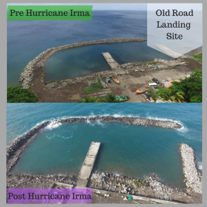
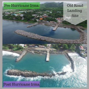
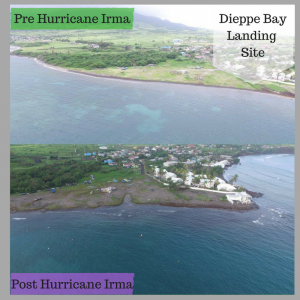
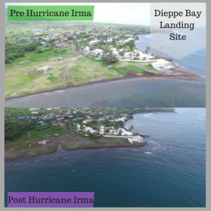
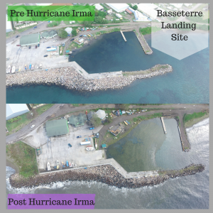
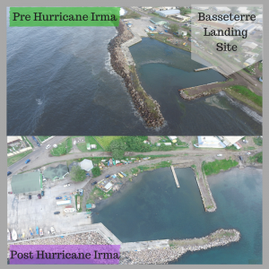
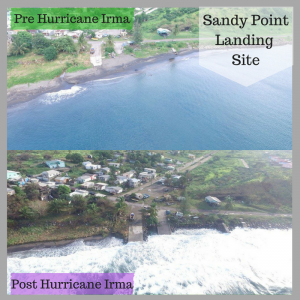
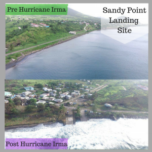
Traditionally, our fish landing sites are found along the coastlines of St.Kitts and Nevis. The major landing sites in St. Kitts are Dieppe Bay, Sandy Point, Old Road and Basseterre. The major landing sites in Nevis are Newcastle, Charlestown and Indian Castle.

Without barriers of protection the coastlines are vulnerable to the effects of storm surges. Barriers such as coral reefs act as buffers that help waves to break in the ocean before they reach land. As a buffer, the reefs reduce the impact that the waves and storms have on the land. When storm surges have direct impact on the coastline then beach erosion can occur. In this case, beach erosion can cause the removal of sand from the beach by currents or waves. The photos below highlight the damage to the coastlines of local landing sites by Hurricane Irma.

,

Creative Murals promote Awareness

The Department of Marine Resources has embarked on a number of projects to raise the level of awareness for Kittitians and Nevisians of marine life and the importance of the sustainable use of marine resources for 2016.  The marine inspired dumpster project is one of the marquee projects that is expected to visually stimulate the populace.

The Department commissioned Nevisian artist Mr Vaughn Anslyn to conceptualize and execute the project.  The results are as follows:


Before: Outline for the mural

Before: Image Outline

Nevisian artist Vaughn Anslyn working on his masterpiece

Nevisian artist Vaughn Anslyn working on the masterpiece.


Finished Visual on the dumpsters

Finished visual on one of the dumpsters


Murals

This is who we are

Marine Life Dumpster in Day time


The murals feature various types of marine life that can be found in the proposed Narrows Marine Management Area including; Hawksbill Sea turtle, Angel fish, sea grass bed, corals, sea sponges and a sea fan.  The mural project was funded by CamPAM Small Grants with the Department of Marine Resources as the National Implementing Entity (NIE).  CamPAM seeks to support to the management of marine space within the region. Establishing Marine Management Areas (MMA) or Marine Protected Areas (MPA) is used as a regional tool to improve marine management, conserve marine biodiversity, address over fishing impacts, decrease user conflicts, and provide economic alternatives to local coastal communities. This has resulted in substantial knowledge gained on optimal site selection and design, successful outreach approaches, effective management strategies, and appropriate methods to evaluate their effectiveness.  The Department of Marine Resources is presently embarking on establishing a two-mile radius St.Kitts and Nevis MMA .

The marine-inspired dumpsters will be placed at various fish landing sites throughout St. Kitts and Nevis.